The wireless monitoring system is composed of existing automation, wireless transmission, computer management and other technologies. The wireless landslide monitoring and management system in this article mainly consists of three parts: collection control equipment, network transmission layer, remote data monitoring center and other systems.
Acquisition control equipment
High-precision rain sensors, vibration sensors, pressure sensors, GPS displacement precision measuring instruments and other related monitoring equipment can accurately reflect small data changes within the monitoring area.
The high-definition video surveillance system can clearly monitor the occurrence of flash floods and people's escape situations, and save pictures and videos according to relevant needs.
Real-time and efficient early warning release system, including on-site alarm release LED screen and alarm. Once an abnormal situation occurs, the system will release early warning information in real time to improve the quality and timeliness of early warning issuance and reduce casualties and property losses.

Network transport layer
The network transmission of the flash flood and landslide monitoring system consists of three industrial wireless transmission terminal devices: Lora, DTU and route. Using advanced wireless transmission methods such as wbee self-organizing network, GPRS, and 3G can reduce the huge workload caused by wiring and ensure stable, reliable, and timely transmission. Mainly responsible for transmitting the collection information of various front-end centralized control equipment, as well as the front-end environment monitoring and alarm information caused by abnormal faults.
Remote data monitoring center
Monitoring Center The monitoring center consists of three parts: county-level monitoring center, municipal-level monitoring center, and provincial-level monitoring center. The monitoring center is connected to the back-end information collection equipment through the Internet. And through wireless transmission technology, the collected data is analyzed and processed, control decisions are made, and the control center issues alarm information or remote alarm.
Monitoring and hierarchical management
The monitoring center station is composed of mature and reliable geological monitoring dedicated lines or the Internet, SMS servers, network servers, etc. The monitoring center divides the entire system into three levels to form a multi-level monitoring model: provincial level monitoring first level, municipal level level two monitoring, and county level level three monitoring center and its monitoring station. Multi-level monitoring is in line with the characteristics of hierarchical management and unified coordination of flash flood disasters. The data collection business of on-site monitoring stations is governed by the management servers of each county and provincial monitoring center, forming a multi-level monitoring system covering the entire province. Based on Bs service, database architecture, powerful and user-friendly monitoring software interface, it has functions such as real-time information collection, real-time information processing, disaster simulation analysis, geographical data information viewing, disaster risk assessment, real-time release of forecast data, early warning data, heavy rain analysis and other functions. With early warning as the core, the system implements functions such as real-time monitoring, external early warning, early warning release, early warning response, information query and configuration management.
Real-time data collection
The flash flood monitoring system consists of engineering equipment such as rainfall sensors, vibration sensors, pressure sensors, cameras, GPS displacement precision measuring instruments, and a central station. The system adopts flexible flash flood disaster monitoring based on automatic monitoring and supplemented by manual monitoring. The system uses an operator network and has real-time automatic reporting functions of rain sensors, vibration sensors, pressure sensors, cameras and GPS displacement precision measuring instruments. The intelligent software can also remotely receive, store, configure, call and manage real-time data from multiple monitoring points.
We focus on the radar level gauge which plays a central role in data collection. The radar level gauge plays the role of water level monitor in flood control and flood alarm.
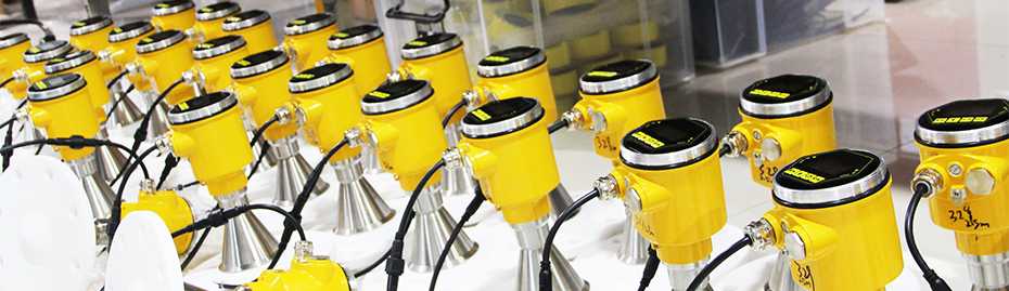
The flood control radar water level meter is a high-precision, low-power non-contact radar water level meter designed by Doweston. It can be used for surface (or pipe network) water level measurement. It adopts pulse coherent radar (PCR) technology, which has higher measurement accuracy, lower power consumption and less volume than traditional pulse radar level meters. Ultra-small product; using 60g sub-millimeter wave as the carrier signal, it has the characteristics of high accuracy, small size, energy saving, etc., and is not affected by temperature. The gradient, air pressure, water vapor, water pollutants, sediment, etc. during the measurement process. The optimized algorithm makes the measurement results more accurate, stable, andSmall size, weight less than 300g, high accuracy, stable measurement up to millimeter level, easy installation and debugging, not affected by temperature and air pressure, maintenance-free algorithm optimization, low power consumption design, not affected by water waves, convenient power supply Features:
1. Millimeter-level high-precision liquid level measurement, ultra-low blind zone;
2. Using its own wave elimination algorithm, the data is stable and not affected by water surface fluctuations and floating objects;
3. No contact, low power consumption, high reliability, maintenance-free.
4. Anti-reverse connection and lightning protection design of the power circuit.
5. Ultra-low power sleep mode, quick wake-up, adaptable to nb Internet of Things applications;
6. Using non-contact mode, the sensor does not come into contact with the water body and is not affected by the hydrological environment;
7. Multiple interface modes (digital simulation) facilitate access to the system;
8. Multiple working modes: cycle, sleep, automatic;
9. Weight is less than 300g, compact and compact; easy to install, and the amount of civil engineering work is small;
10. Micro-antenna design, pulse coherent radar technology, leading technology;
11. IP68 waterproof design, it will not be damaged by water immersion. Application areas: hydrological survey of rivers, lakes, reservoirs and other rivers, water level monitoring of urban flood control, drainage, underground pipe networks, etc., monitoring of heavy rains and floods in mountainous areas, etc. Technical parameters:
Wireless publishing
The flash flood and landslide monitoring software completes the data collection function of all engineering equipment within its jurisdiction. The factual information such as rainwater information, mountain vibration, and video images collected by the back-end equipment is collected into the monitoring software of the county-level monitoring center. The data collected by the field equipment is analyzed and processed, and then the data is saved in the database of the monitoring software to facilitate subsequent data analysis and comparison. Since the system adopts multi-level management, the county-level monitoring center shares real-time collected data to the municipal-level monitoring center and provincial-level monitoring center to realize the linkage of flash flood monitoring information, allowing managers of government departments at all levels to make corresponding emergency decisions.The county-level monitoring center automatically analyzes real-time collected monitoring information such as heavy rain, mountain ponds, and soil quality, and issues forecast warnings in a timely manner. It also uses high-frequency alarms and LED displays configured in the village to issue early warning information. When abnormal information occurs, the workflow after the warning information is: new warning → external warning → issue warning → response starts → response ends. Based on early warning and information release, relevant departments initiate corresponding emergency implementation plans until the response is completed.
Mass alarm system
The SMS sending and receiving system is directly controlled through the flash flood disaster early warning software interface. If there is any abnormality, the SMS group sending function will be automatically triggered. Automatic early warning information and response instructions are sent to responsible departments and persons in charge through the SMS server group of the monitoring center, and real-time feedback from departments and persons in charge is received. Managers send and receive information based on SMS messages, execute remote operation instructions, and use the SMS group sending interface provided by the operator to provide early warning and mass messaging to protect the personal safety and property safety of the masses.





 Home


